
Top of Dent de Vaulion - from Vallorbe to Le Pont
- Marietta Galazka
- Aug 25, 2020
- 3 min read

Vaud Canton, Vallorbe


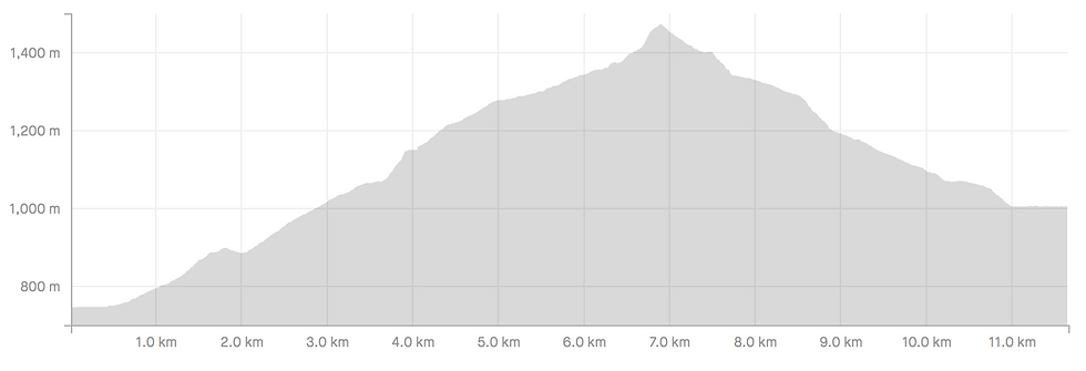
Distance: 11.65 km.
Walking time: 3h 35 min. (Schweiz Mobil website suggests 4h 35min from Vallorbe train station).
Elevation gain: 760 m.
Highest point: 1,483 m.
Access: Car, train or bus.
Train: Get off at Vallorbe.
Bus: Vallorbe or Vallorbe Poste.
Parking: At Rue de l'Orbe - 46.710259, 6.378793
Way back: Train from Le Pont to Vallorbe. Train timetable & fares can be viewed here.
What an experience! Our destination was the summit of Dent de Vaulion from Vallorbe, knowing that we have a big ascent of ~750m + to overcome. The summit is accessible with a smaller elevation gain from Le Pont (~600m) or from the parking at the top (~73m). We chose this route, because it is the official "Jura Crest Trail" stage 13, route no. 5. The top of Dent de Vaulion has a unique view, because all 4 lakes are visible - Lac Léman, Lac Neuchâtel, Lac de Joux and Lac Brenet. I wish it was possible to fit them all into 1 photograph! We could easily spend the day staring at those views. We passed a few hikers on the way up and down, cyclists and runners. The top is also accessible by car, so there were a lot of tourists around, including small babies in baby backpacks and carriers. On this route, we came across: a horse, a donkey, a giant snail, an ermine (so we think), plenty of cows, singing birds (including a woodpecker) - they all made our toddler happy!
There were a few picnic tables on the way up and at the top. It was also easy to set up a picnic around the meadows or at the top too. There is a Buvette shortly below the summit (at the parking). Vallorbe and Le Pont have plenty of restaurants and cafes too. On the way down to Le Pont, we passed a self-service fridge with local cheeses.
The trail is marked in yellow, however I think that the last ascent should have a mountain path mark (colour marks are explained here). The route type varied between a forest way, tarmac road, meadow paths, gravel trails and large stones.
The first part of the ascent was not as pleasant; while the second part of it was very enjoyable. The first 4 km were tough, through the forest and the views were not visible for the majority of the way. The remaining 3 km seemed smoother and nice. The path opened up between the meadows until reaching the ridge with a large fall on either side. The ridge was secured with trees and bushes, so it felt rather safe. The last climb was very steep and with a bit of rock climbing. We managed well with climbing upwards, but we would not feel confident climbing downwards with our baby backpack.
The summit was quite spread and each side offered a completely different, stunning view. Dent de Vaulion is definitely a special place and it is not common to see all those lakes in one view. We wish we prepared better and that we could have stayed a little longer at the top.
The descent was much smoother than the ascent and views were accessible for most of the way. The start was quite steep, but it got smoother rather fast. A few times, there were options of either following a smaller gradient, gravel road or steeper shortcuts. The path ends at the Lac de Joux and follows through the shoreline and next to the picturesque village Le Pont.
In addition to the hiking routes, Vallorbe offers attractions such as Stalactite Caves, iron & railway museum, WW II fortress.
Le Pont is part of a Federal Inventory of Swiss Heritage Sites of national importance (ISOS). It is a romantic, touristic village offering rentals for kayaks, pédalos and canoes.
For more information about the walk from the top parking to the summit, visit our post "Top of Dent de Vaulion - viewpoint".
More information about this route can be found on SchweizMobil website here. More information about Vallorbe village and other attractions can be found on MySwitzerland website here or Vallorbe website here. Activities around Le Pont and Lac de Joux can be found on Vallée de Joux website here.


Comments